Constanta
The Port of Constanta is located at the crossroads of the trade routes linking the markets of the landlocked countries from Central and Eastern Europe with the Transcaucasia, Central Asia and the Far East. It is the main Romanian port and it ranks among the first 10 European ports. The favorable geographical position and the importance of the Port of Constanta is emphasized by the connection with two Pan-European Transport Corridors: Corridor VII – Danube (inland waterway) and Corridor IV (rail-road). The two satellite ports Midia and Mangalia that are located not far from Constanta Port are part of the Romanian maritime port system under the Maritime Ports Administration SA Constanta coordination.
The Port of Constanta is one of the main distribution centers for the Central and Eastern Europe, offering many advantages, of which mention must be made of:
– Multi-purpose port with modern facilities and sufficient water depths in the port basins to accommodate the largest vessels passing through the Suez Canal;
– Direct access to the Central and Eastern European countries through the Pan-European Corridor VII – the Danube;
– A hub for the container traffic in the Black Sea;
– Good connections with all modes of transport: railway, road, river, airway and pipelines;
– Customs facilitations for commercial operations performed through the Port of Constanta;
– Modern facilities for passenger vessels;
– Land availability for future expansion;
– Since 1st January 2007, the Port of Constanta has become Free Zone.
Maritime Port
The Port of Constanta is located on the Western coast of the Black Sea, at 179 nM from the Bosphorus Strait and 85 nM from the Sulina Branch, through which the Danube flows into the sea. It covers 3,926 ha of which 1,313 ha is land and the rest of 2,613 ha is water. The two breakwaters located northwards and southwards shelter the port creating the safest conditions for port activities. The present length of the North breakwater is 8,344 m and the South breakwater is 5,560 m. Constanta Port has a handling capacity of over 100 million tons per year and 156 berths, of which 140 berths are operational. The total quay length is 29.83 km, and the depths range between 8 and 19 meters.
These characteristics are comparable with those offered by the most important European and international ports, allowing the accommodation of tankers with capacity of 165,000 dwt and bulk carriers of 220,000 dwt.
Currently, there are several projects in progress, in order to build new facilities for cargo handling and to improve the transport connections between Constanta Port and its hinterland. These projects are mainly located in the South part of the port
River Port
Constanta Port is both a maritime and a river port. Daily, more than 200 river vessels are in the port for cargo loading or unloading or waiting to be operated. Facilities offered by the port allow accommodation of any type of river vessel.
The connection of the port with the Danube River is made through the Danube-Black Sea Canal, which represents one of the main strengths of Constanta Port. Due to low costs and important cargo volumes that can be carried, the Danube is one of the most advantageous modes of transport, an efficient alternative to the European rail and road congested transport.
Important cargo quantities are carried by river, between Constanta and Central and Eastern European countries: Bulgaria, Serbia, Hungary, Austria, Slovakia and Germany. River traffic is very important for Constanta Port.
Touristic Port – Tomis Marina
Tomis marina is integrated in a harmonious manner with the architectural design of Constanta city and it represents a prolongation of the Casino cliff and a balanced transition to the city beach. Access from the city to the port can be easily made by vehicles and on foot. A series of touristic objectives of great interest can be found close to the Tomis marina: the Ovidiu Square bearing the name of the Roman poet Ovid, the Archaeological Museum, the Roman Mosaic with ancient relics of old Tomis, the Aquarium, the Genovese Lighthouse, the Casino.
Due to its favorable location and present infrastructure, Tomis marina has a high potential for nautical tourism, sporting activities and entertainment, representing a shelter for sport sail ships. The capacity of the port allows the arrangement of sporting activities such as boat races.
At present Port Administration is developing an investment project regarding the modernization of Tomis marina, having in view the rehabilitation and extension of the breakwaters to create a safer port and also increase its functionality and services.
Tomis Marina is to become an important destination for coastal pleasure boats sailing along the Romanian sea shore with calls at Eforie, Costinesti, Neptun, Mangalia or northwards Mamaia and Midia.
Port limits:
As the commercial limits, the port of Constanta is confined by the North and South breakwaters.
Traffic Separation Zone (TSS):
The traffic separation scheme for arriving into and departing from the port is as follows:
1. The separation zone has the following limits:
44°04.75’N 028°43.77’E
44°04.44’N 028°43.22’E
43°59.40’N 028°48.60’E
43°59.70’N 028°49.17’E
2. The entrance channel into the port has the general direction NW, True course is 322°
44°00.19’N 028°50.04’E
44°05.24’N 028°44.65’E
3. The departure channel from the port has the general direction SE, True course is 142°
44°03.96’N 028°42.35’E
43°58.90’N 028°47.74’E.
The observance of 1972 COLREG is compulsory. The length of the navigational channel is 6.4 Nm, depth is 21 m. The breadth of the navigational channel is 0.8 Nm.
The width of the separation zone is 0.5 Nm.
Pilotage: Compulsory for all vessels, except navy vessels, vessels used in public service, vessel for maintenance or for the control and surveillance of navigation, intervention vessels, training, hospital and pleasure vessels. Pilotage is compulsory for berthing, unberthing, shifting and is available 24 hours / day.
The vessel’s Master has to contact Constanta VTS / VHF Ch 67 at the entrance into the jurisdiction zone (12 Nm radius from position: 44°10.20’N 028°39.60’E).
Pilot can be contacted in VHF Ch 14. The language used is English. The compulsory zone for embarking/disembarking of pilot is:
In fair weather (the wind force up to 4): within the circle with a radius of 0.5 Nm from position: 44°05.06’N 028°43.06’E.
In bad weather (over force 4) near the position 44°06.24’N 028°42.30’E.
Density: 1014
Weather: Prevailing winds: beginning with October and all winter, there are strong northerly winds (up to 9 to 10 Beaufort).
In the summer time, variable winds, sometimes rainfalls.
Maritime signaling system:
The Romanian maritime ports are provided with a modern maritime signaling system: light buoys and radar reflectors.
Charts: BA 2284. Admiralty Pilot NP19
The traffic plans:
The master of the vessel is obliged to be in permanent contact with Constanta VTS (VHF Ch 67), starting from the vessel’s entrance into the jurisdiction zone,
at anchor also. Entering/leaving in/from the port and also the manoeuvres inside the anchorage zone will be made with the approval of the Constanta VTS only.
Radar: Radar surveillance is permanently performed by Constanta VTS on 12 Nm radius area.
Restrictions: Entrance to the port during night-time is forbidden for tankers with a draft over 11 m.
Tug assistance is compulsory for any vessel over 1,000 NRT.
Search and rescue (SAR): In the Romanian ports zone on the Black Sea the SAR operations are provided by ARSVOM (Romanian Association for the rescue
of human life at sea – Constanta), with two tugs: ”Hercules” (6.600 hp) and ”Viteazul” (2.400 hp), and also, 11 SAR launches.
Anchorage: The roadstead of Constanta is limited by the following co-ordinates:
44°10.50’N 028°44.00’E
44°10.50’N 028°49.50’E
44°06.50’N 028°49.50’E
44°06.50’N 028°44.00’E.
The meridians of 028°46.7’E and 028°48.2’E divide the anchorage into 3 zones, numbered from West to East:
Zone 1: Anchorage for vessels up to 40,000 GRT (except tankers)
Zone 2: Anchorage for vessels over 40,000GRT (except tankers)
Zone 3: Anchorage for tankers, LPG carriers and vessels carrying dangerous cargoes
The roadstead allows safe anchorage, with depths of 25-30m for 40 to 50 large ships, with the possibility to make a full swing in case of change of wind or current direction. In bad weather, small vessels may enter the port waters with the approval of the Constanta VTS only.
Tide: Tidal variations are insignificant. In case of strong and persistent winds, high tide may be 0.5 m above the reference. The drifts direction is form North to South at a speed of more or less 1 knot.
General Information for all vessels:
- ETA / ETD;
- Vessel’s name / former names/ call sign / flag;
- IMO number / MMSI number;
- Type of vessel / year of built;
- GRT, NRT, DWT, LOA, breadth;
- Maximum draft, arrival draft, intended departure draft;
- Owner’s / Operator’s / Charterer’s name and address;
- Agent’s name and address;
- Master’s full name;
- Number of crew (including master) / number of passengers;
- Purpose of call;
- Last port of call / next port of destination;
- Cargo on board, cargo to be discharged / loaded, quantities / hatch distribution. (if dangerous cargo, UN number / class in accordance with IMDG or IBC, BCH, IGC, INF Code must be specified);
- Quantity of ballast to be discharged and provenance;
- Capacity of sludge / bilge tanks, Quantity of sludge / bilge;
- Ship’s statutory certificates expired on arrival;
- Validity of ISM certificates (DOC, SMC);
- Date and place of last PSC report;
- Any deficiency of hull machinery or equipment wich may affect safe manoeuvrability of the vessel, affect the safety of the other vessels, constitute an hazard to the marine environment, to person or property;
Supplementary information for tankers only
- Whether gas free or in an inert condition;
- Validity of Civil liability Certificate (for tankers of more than 2,000 dwt.);
- Quantity of segregated / clean / dirty ballast on board;
- Quantity of ballast to be delivered ashore;
- Capacity / quantity of slop tanks;
- COW time, if to be performed
Required documents
On vessel’s arrival/departure, the port authorities require the following IMO standard FAL documents:
- 5 (copies) IMO General Declaration,
- 5 (copies) IMO Cargo Declaration
- 3 (copies) Ship’s Stores List
- 2 (copies) Crew Effects Declaration
- 5 (copies) Crew List
- 5 (copies) Passenger List
- 2 (copies) Cargo Plan
- 1 (copy) Maritime Declaration of Health
- 1 (copy) Derat Certificate, Derat Exemption Certificate
- 1 (copy) Phytosanitary Declaration
- 2 (copies)Sanitary-Veterinary Declaration (in case of vessel carry perishable and agricultural cargo, live animals etc.)
The FAL documents will be dated and signed by Master, authorized Agent or Officer. In addition to the above, the following documents have to be available on board:
1. For all ships:
- Certificate of Registry
- International Tonnage Certificate
- International Load Line Certificate
- International Load Line Exemption Certificate
- Stability Information for Passenger Ships and Cargo Ships
- Minimum Safe Manning Certificate
- Certificate for Masters, Officers and Ratings
- International Oil Pollution Prevention Certificate:
- Record of Construction and Equipment for Ships other than Tankers
- Record of Construction and Equipment for Oil Tankers
- Shipboard Oil Pollution Emergency Plan
- Document of Compliance (copy)
- Safety Management Certificate
2. In addition to the requirements in the section 1, the passenger ships must have on board:
- Passenger Ship Safety Certificate
- Record of Equipment for the Passenger Ship Safety Certificate
- Exemption Certificate
- Special Trade Passenger Ship Safety Certificate
- Special Trade Passenger Ship Space Certificate
3. In addition to the certificates mentioned in the section 1, the cargo ships must have on board:
- Cargo Ship Safety Construction Certificate
- Cargo Ship Safety Equipment Certificate
- Record of Equipment for the Cargo Ship Safety Equipment Certificate
- Cargo Ship Safety Radio Certificate
- Record of Equipment for the Cargo Ship Safety Radio Certificate
- Exemption Certificate
- Document of Compliance with the Special Requirements for Ships Carrying Dangerous Goods
- Dangerous Goods Manifest or Stowage Plan
- Document of Authorization to Load Grain
- Certificate of Insurance or Other Financial Security in Respect of Civil Liability for Oil Pollution Damage
4. In addition to the requirements mentioned in sections 1 and 3, all ships carrying noxious liquid substances must have on board:
- International Pollution Prevention Certificate for the Carriage of Noxious Liquid Substances in Bulk (NLS Certificate)
- Cargo Record Book
5. In addition to the requirements mentioned in the sections 1 and 3 all tankers for chemical products carriage must have on board:
- Certificate of Fitness for the Carriage of Dangerous Chemicals in Bulk (or International Certificate of Fitness for Carriage)
- Certificate of Fitness for the Carriage of Liquefied Gases in Bulk(or International Certificate of Fitness for the Carriage of Dangerous Chemicals in Bulk)
6. In addition to the requirements mentioned in the sections 1 and 3, all the tankers for liquefied gases carriage must have on board:
- Certificate of Fitness for the Carriage of Liquefied Gases in Bulk (or International Certificate of Fitness for the Carriage of Liquefied Gases in Bulk)
7. In addition to requirements mentioned in the sections 1 and 3, all the high speed craft must have on board:
- High Speed Craft Safety Certificate
- Permit to Operate High Speed Craft
Other Certificates
Special Vessels
- Special Purpose Ship Safety Certificate
- Additional Certificate for Offshore Supply Vessels Carrying Limited Quantities of NLS in Bulk
Diving Systems
- Diving System Safety Certificate
Dynamically Supported Craft
- Dynamically Supported Craft Permit to Operate
Mobile Offshore Drilling Units
- Mobile Offshore Drilling Unit Safety Certificate
Noise Survey
- Noise Survey Report
Note: All the certificates required on board must be original.
Working Hours
- Monday – Friday: 1st shift – 07.00-19.00, the 2nd one 19.00-07.00.
- Saturdays, Sundays and holidays: It is possible to work on these days and the ship’s operation tariffs are negotiable. However the working schedule, the shifts, over-time and rest-time can be different, depending on the port operator, and suggestion is made to contact the local sources for any programming activities.
Public Holidays
- 1st and 2nd of January
- Easter holidays (two days)
- 1st of May
- Pentecost Day (24th of June)
- St. Mary’s Day (15th of August)
- St. Andrew’s Day (30th of November)
- National Day (1st of December)
- Christmas holidays (25th and 26th of December)
- Saturday and Sunday
Owners / Masters Notification
As per EU and Romanian legislation en force, in order to avoid penalities or any other unpleasant situation during port call Owners / master should comply following rules:
1. Owners / Master to send the pre arrival templates (MSW forms), at least 24 hours prior arrival the vessel in the port otherwise vessel will not get port entrance approval from port authorities and Harbour Master applies penalities from 250 Euros to 500 Euros.
2. Owners / Master must fill up all necessary / empty spaces in the notifications, otherwise port authorities apply Owners / Master penalities between 250 Euros and 750 Euros.
3. In case requested information regarding Bunkers Convention Certificate are not filled up, Harbour Master might refuse vessel’s entrance in the port.
4. In case vessel has no available Bunker Convention Certificate, Harbour Master applies penalties from 2.500 Euros up to 12.500 Euros, and might also stop vessel’s operations in the port till certificate is obtained.
5. Master to fill up in log book transfer operation for consumption of main engine from marine fuel with content of sulphur exceeding 0.1% m/m to marine fuel (gas oil) with content of sulphur not exceeding 0.1% m/m. If this is not mentioned in the log book, Harbour Master applies penalty from 2.500 Euros up to 5.000 Euros.
6. In case of any penality is applied by port authority vessel is not allowed to sail from the port till the amount is fully covered by Owners / Master.
The original Certificate of insurance or other financial security in respect of civil liability for bunker oil pollution damage must be on board of the vessel.
As per provisions of Directive 2009/20/EC of the European Parliament and of the Council of 23 April 2009 on the insurance of shipowners for maritime claims, published in the Official Journal of the European Union (OJEU) No. L 131 of 28 May 2009, which provides for the mandatory carriage of the insurance certificates for maritime claims on board the ship, staring 03.04.2012 all vessels calling Romanian ports MUST have MARITIME CLAIMS INSURANCE. The absence on board of the insurance certificates for maritime claims, vessel has 72 hrs to provide such certificate and then will lead to possible no acceptance in the port or ship expulsion by Romanian Port Authority
Mangalia
The Port of Mangalia is situated on the Black Sea, close to the Southern border with Bulgaria, and over 260 km N of Istanbul. It has an area of 142.19 ha of which 27.47 ha is land and 114.72 ha is water.
The N and S breakwaters have a total length of 2.74 km. There are 4 berths (2 operational berths) with a total length of 540 m. The max. depth is 9 m.
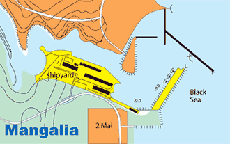
Main cargoes:
iron ore; oil products; mineral products.
Load Line zone:
Summer
Communications:
VHF: Ch 16 and 14
General notices & regulations:
Vessels carrying toxic materials, explosives and inflammable materials are prohibited from entering the roadstead and port.
Foreign vessels are prohibited from entering the N basin, Mangalia Lake and the channel connecting the basin to the lake.
Sea buoys, fairways and channels:
From the vicinity of position 43°48'N 028°50'E the recommended approach route leads due W for 9nm to the harbour entrance, passing S of the harbour entrance light buoy (starboard hand) (0.25nm SE of NE breakwater head), then S of NE breakwater, the SE extremity of which is marked by a lighthouse (cupola on grey metal framework tower, 21m in height) and into Mangalia harbour the entrance of which is marked by lights (cupola on grey stone and concrete dwelling, 13m in height).
Caution: Attention is drawn to a rock, with a depth of 0.4m over it, that lies 0.2nm S of the SE breakwater head.
Pilot:
Compulsory. Vessels should send request for pilot at least 2 hours before:
1. Arrival in the roads
2. Moving within the port
3. Leaving the port
Anchorages:
Anchorage is available in the roads 1.5 nm NE of the harbour entrance. The anchorage area has depths of 17-22 m.
Tidal range and flow:
Range 0.3 m. Current: In normal weather the current sets S off the harbour entrance at a rate of 0.5 km. The current extends for approx 3 nm offshore where its outer limit can be distinguished, as the water forming the current is darker in color.
Dock density:
1025
Weather:
Prevailing winds: Variable.
Principal lights:
| Location | Characteristics | Range (nm) | Structure/Height(m) |
|---|---|---|---|
| Mangalia Main Light: 43°48'.7N 028°33'.6E | FI (2) W5 5s | 22 | White pyramidal stone tower (42) |
| Entrance Light NE Breakwater Head 43°47'.9N 028°36.1'E | FI W 4s | 10 | Cupola on grey framework tower (21) |
Charts:
BA 2230, 2282, 2284. Admiralty Pilot NP24.
Tugs:
1x600 HP and 1x2,400 HP If more tugs are required the can be supplied from Constanta.
Berths Information:
| Berth | Length (m) | Max depth (m) | No of berths | Location |
|---|---|---|---|---|
| General cargo | 419 | 9.0 | 2 | berth 1, 2 |
| Technical Vessels Berth | 105 | 5.5 | 1 | berth 4 |
| Fitting-out Berth | 95 | 5.5 - 9.0 | 1 | berth 3 |
Facilities:
Quay cranes available: 1 x 120t, 3 x 50t, 1 x 15t, 4 x 6.3t.
Storage:
Open storage of 20,000 sq.m and covered storage of 4,300 sq.m available.
Midia
The Port of Midia is located on the Black Sea coastline, approx 13.5nm N of Constanta. It is one of the satellite ports of Constanta and was designed and built to serve the adjacent industrial and petrochemical facilities.
The N and S breakwaters have a total length of 6,97 m. The port covers 833,9 ha of which 233,7 ha is land and 600,1 ha is water. There are 14 berths (11 operational berths, 3 berths belong to Constanta Shipyard) with a total length of 2,24 km.
Further to dredging operations performed the port depths are increased to 9 m at crude oil discharging berths 1-4, allowing access to tankers having a 8,5 m maximum draught and 20.000 dwt.
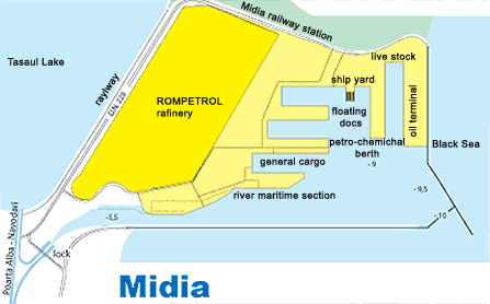
Main cargoes:
Oil products and natural gas; crude oil; iron ore; lime, cement, construction materials; live stock.
Connections :
road, railway, inland ( via Poarta Alba-Midia Navodari Canal)
Communications:
Radio Constanta, callsign ”YQI”, working frequency: 500kHz; 461kHz; 2,748kHz. VHF: Harbour Master, Midia, Ch 67.
Health regulations:
Sanitary Inspection: Immediately after berthing, the Sanitary Commission checks the condition of health of all the personnel on board, the nature of cargo, specifications regarding possible diseases, vaccinations, etc. If there is no contamination danger, free pratique is granted to the vessel.
Port limits:
The port is limited by the S and E breakwaters
Sea buoys, fairways and channels:
The port is accessed through an approach channel with a width of 80 m and a depth of 5.6m.
Pilot:
Compulsory for all vessels, except Navy vessels, vessels used for a public service such as maintenance, control and surveillance of navigation, salvage vessels, training, hospital and leisure vessels. Pilotage is compulsory for entering, leaving the port and for the maneuvering of the vessels inside the port, throughout 24 hours. The vessel's Master has to notify pilots, at least 12 hours prior to arrival. The vessel's Master will contact Constanta Port State Control at the entrance into the zone of 12nm from the N jetty, calling on VHF Ch 14.
The compulsory zone to embark/disembark the pilot is as follows:
Fair weather (wind force 4), near the point of co-ordinates: 44°05'.1N 028°43'.1E.
Bad weather (wind over force 4), near the point of co-ordinates: 44°06'.2N 028°42'.3E.
The pilot boat is white, with ”pilot” on the side.
Anchorages:
Anchorage is available at the following co-ordinates:
The depth in the anchorage area is 20 m.
| Latitude | Longitude |
|---|---|
| 44°22'.0N | 028°45'.5E |
| 44°22'.0N | 028°48'.5E |
| 44°19'.5N | 028°45'.5E |
| 44°19'.5N | 028°48'.6E |
Tidal range and flow:
Tides in the Black Sea are negligible. Variations of water level may be caused by persistent winds and can reach 0.5m under extreme conditions.
Dock density:
1014
Weather:
Prevailing winds: Winter, N-NE; Spring, NE-E and NE-S; Summer, NW-NE; Autumn, N-NE.
Strong winds occur at the end of autumn (Oct) and in winter (Jan) with storms up to Beaufort force 9 to 10 (20kn to 30kn).
Main navigational aids:
Along the Romanian coast, from Midia to Mangalia there are modern navigational aids with solar cells, remote control and radar reflectors.
Principal lights:
| Location | Characteristics | Range(nm) | Structure/Height(m) |
|---|---|---|---|
| MidiaMain Light: 44°20'.9N 028°41'.1E | FIW 5s | 17 | Whitecupola on a metal framework tower with red and white bands (22) |
| EntranceLight (offshore breakwater head) 43°47'.9N 028°36.1'E | FIW 4s | 10 | Metalstructure on white concrete (18) |
Charts:
Admiralty Pilot NP24.
Restrictions:
Tankers are not permitted to enter at night
Tugs:
There is a tug of 600 hp available (owned by Black Sea Shipping). More tugs can be ordered from Constanta.
Coast guard:
There is a salvage group, with 2 tugs: ”Hercules” (6,600 hp) and ”Viteazul” (2,400 hp). The salvage group is able to act as coastguard along the Romanian Coast and in international waters.
Mooring information:
There are no unusual berthing maneuvers.
Berths Information:
| Berth | Length(m) | Maxdepth (m) | Cargo |
|---|---|---|---|
| 1- 4 | 532 | 9.0 | Crudeoil |
| 5- 8 | 637.6 | 9.0 | Livestock |
| 9 | 204 | 9.0 | Petroleumproducts |
| 10- 11 | 191.3 | 9.0 | Generalcargo |
| 3berths belong to Constanta Shipyard | Shipmaintenance and repair | ||
Facilities:
Quay cranes 2 x 6.5 t ( 1x 10t - Global Op.).
Storage:
Warehouses = 3 x 720 = 2.160 sq.m. and platform = 10.780 sq.m.
Barges:
There is a river-maritime access in the port via Danube-Black Sea Canal (Poarta Alba - Navodari branch).
Braila
Geographical position
Latitude: 45°15'N Longitude: 027°59'E
Location
The Port of Braila is a river - maritime port on the Danube. It is situated on the left border of the Danube between Km 168+300 si Km 170+875.
Anchorage
The anchorage zones are established between Km 167 - 168 for the seagoing and river vessels and at Km 175 m for river vessels
Port Sectors
- Old Port (Km 169,8 - Km170,875) having 8 berths equipped with floating pontoons and used for passengers, fresh water supply, loading and discharging general cargoes by floating cranes and ship’s gear.
- Docuri Port - Has 496 Km of pier on Danube front and 1,568 m of pier at basin. Main commodities are grains ex silo, bulk and general cargoes by shore cranes.
- Downriver of Docuri Bazin – Has a 396 Mt. of pier at Danube waterfront use for passengers traffic
| Berth | Length[m] | Depth[m] | Use |
|---|---|---|---|
| Old Port: | |||
| 17-19 | 225 | 2,50 | Service ships |
| 20-23 | 700 | 3,50 | General cargoes |
| 24 | 105 | 7,30 | General cargoes |
| Docuri Port: | |||
| 25-27 | 496 | 3,5 | General cargoes by floating cranes or ship’s gear. |
| 30-32 | 300 | 3,5 | Stones and paving and constructions materials |
| 33 | 145 | 3,5 | Ship repairs |
| 34-38 | 558 | 7,3 | General cargoes |
| 39 | 210 | 3,5 | Service ships |
| 40 | 211 | 3,5 | Ship repairs |
| Zona Aval Bazin Docuri: | |||
| 42-44 | 396 | 3,5 | Ro-ro and passengers |
Galati
Geographical position
Latitude: 45°25'N Longitude: 028°05'E
Location
The Port of Galati is the main Romanian river - maritime port on the Danube. It is situated on the left border of the Danube between Km 160 and Mm 76.
Anchorage
The anchorage zones are established between Mm 76 - Mm 78.5, Km 155 - Km 158 for the seagoing and river vessels and between Mm 80 - Km 150 and Km 158.2 - Km 159.3 for the empty river vessels.
Winter Lakes
The winter lakes are located in the Docuri Harbor and in the New Basin Harbor.
Port Sectors
The Port of Galati has four main specialized sectors: - Mineral Port - located within Km 155.4 and Km 157.6.It is specialized for ore, coal, coke, limestone rolled goods. - Old Commercial Port located within Km 149.34 and Km 151. It is specialized for passengers and ballast traffic. - Docuri Basin located within Mm 80 and Km 149.35. It is specialized for general cargo, bulk and cereals. - New Basin located within Mm 78+1300 and Mm 79+700 It is specialized for timber, rolled goods, ore, coal and coke.
Meteorological Information
Very hot summers and cold winters characterize the lower Danube basin. Maximum summer temperatures vary between + 35°C and +40°C and average summer temperatures are between +25°C and +22.4°C. Minimum winter temperatures vary between - 20.2°C and - 28.6°C and average winter temperatures vary between - 5.7°C and -1.7°C. Prevailing winds are from the North - Northeast and Southeast during winter and spring months. Average wind velocity is between 1 and 4m/sec. Wind velocity 10 to 15 m/sec occur between 1% and 5% of the time. Snowfall is not uniformly distributed but varies between 50 and 80 cm for approximately 30 days / year. Fog (particularly during cold periods) an average 55 days / year.
Partial freezing of the river can commence in January and usually ceases in February. However no freezing has been recorded in the past five years. It is reported that current velocities in the river vary between 2.29 and 2.36 Km / hr for medium water levels and between 5.95 and 6.04 km / hr during flood levels.
Water Levels
It is understood the reference level adopted to determine the minimum depth of the Danube is the navigation and training works Low Water Level (L.W.L), which is the level, exceeded for 94% of the time for the entire navigable length from Regensburg to Sulina.
Navigation from the river mouth to Galati is defined as Fluo Maritime and the minimum depth at 94 % L.W.L is defined as 7.32m
At Galati the level "0 " on the gauge scale is 0.86 m above Black Sea Datum and it is reported that during spring floods (snow melting period) the water level in the river can rise to 7.30 m above Black Sea Datum.
From the water data it would seem that make maximum use of water depths in the river downstream of Galati the minimum depth of water to be provided at the new berths should be 7 m. The maximum water depth during spring floods would then be in excess of 13.5 m.
Terminals and Berth details
| Measure | Mineral Port | Old Commercial Port | Docuri Basin | New Basin | |
|---|---|---|---|---|---|
| Berth | No. | 1-16 | 11-13, 18-21, 7-10,15-17,22 | 23-33 | 36-50 |
| Length of the quay | M | 2,000 | 1,677 | 1,365 | 1,980 |
| Depth (min) | M | (-4) - (-7.3) | -3.5 | -6.5 | -6.0 |
| Equipment - quay cranes | Pcs. | 42 | - | 17 | 10 |
| Platform area | Sq. m. | 44,380 | 8,220 | 38,100 | 167,730 |
| Vessels Capacity | Tdw | 25,000 - 3000 | - | 8,000 | 8,000 |
Tulcea
Geographical position
Latitude: 45°10'N Longitude: 028°49'E
Location
The Tulcea Harbour complex is situated on the right bank of the Danube, between km 73,5 and km 70,0 along the sea-wall town and comprise the Industrial Port and Commercial Port. The Commercial Port of Tulcea is destined also for passengers traffic and serves entirely the Danube Delta Zone.
Industrial Port
The Industrial Port in Tulcea is located at km 73,5 on the Danube being built starting with 1974 in order to provide the necessary raw materials for the metallurgical plants in Tulcea. Main activities of Industrial Port are:
- Unloading the imported raw materials as manganese, limestone, quartzite, bauxite, chrome, iron and coke from sea going vessels;
- Unloading the quarry ballast products from barges;
- Loading the exported raw materials as ferroalloys, scrap iron and alumina;
Maritime Berths
- 2 maritime quays for receiving and expedition of ferroalloy and concrete gantry transports;
- An operating length of 230 m;
- Endowed with portal cranes ( KANGUR type - 16 tf x 32 m ) equipped with grippers;
- Cranes opening : 15.30 m;
- Storage capacity : platform - 8.000 sqm;
River Berths
- 1 river quay for receiving ferroalloys and concrete gantry transports;
- An operating length of 100 m;
- Endowed with portal cranes ( KANGUR type - 16 tf x 32 m ) equipped with grippers;
- Cranes opening : 15.30 m;
- Storage capacity : platform - 3.000 sqm;
Commercial Port The Commercial Port in Tulcea comprises two sectors:
- Down the Oceanic Fishing Port - berths specialized for general goods and passengers traffic;
- At km 70,0 - berths specialized for ballast products;
River berths
- 3 river quays for receiving and expedition general goods with a length of 300 m, fitted with portal cranes ( BOCSA and WB type - 16 tf x 32 m/ Cranes opening: 10.875 m) and having a storage capacity: platform - 12.000 sqm;
- 4 river quays destined for passengers traffic with an length of 400m;
- 1 river quay for receiving and expedition ballast products with an length of 120 m, fitted with portal cranes ( BOCSA and WB type - 16 tf x 32 m /Cranes opening: 10.875 m) equipped with grippers and having a storage capacity: platform - 2.600 sqm;
Sulina
Geographical position
Latitude: 45° 10' N Longitude: 029° 40' E
Time Zone: GMT +2
Max. Draft: 7.32 m
UNCTAD code: ROSUL
PORT DESCRIPTION
Location: Sulina is situated at the mouth of the Danube, 148km E of Constanta.
General overview: Depths in the canal range from 10m to 14m, permanent dredging allows vessels of max draft 7.32m to berth. Ice may form during Feb and Mar, but the port is kept open by icebreakers. Fog may be encountered during Dec and Jan. Draft restriction on the canal is give by Sulina bar draft, area where continuous dredging is performed. For checking of the Sulina max. allowable draft at a certain time please contact us.
Load Line zone: Summer Zone for ships over 100m in length and Winter Seasonal Area for ships of 100m or less in length, Winter Dec 1 to Feb 28/29, Summer Mar 1 to Nov 30.
NAVIGATION
Sulina Port limits: The seaward limits of Rada Sulina, extend 2nm between N and ESE from the seaward end (Lat 45°08'N, Long 029°48'E) of the protected canal. Upstream the port area extends to 3nm.
Sea buoys, fairways and canals: The port area is approached by a canal, 4nm in length, which has a bar at its seaward end. The canal is protected by N and S breakwaters.
Directions: Initial position: In the vicinity of the No 1 light buoy (safe water) (Lat 45°08.1'N, Long 029°47.7'E).
Leading marks: The alignment (301°) of light beacons standing on the elbow of the N breakwater: Front light (yellow daymark, black stripe) (Lat 45°09.9'N, Long 029°43.4'E).
Rear light (yellow daymark, black stripe) (220m NW of front light) leads along the centerline of the canal passing between a pair of light buoys marking the entrance to the canal and passage across the bar and thence between the breakwater heads which are marked by lights (white framework tower, 9m in height).
Pilot: Compulsory. Pilot boards in the roadstead, usually during daylight hours only.
Anchorages: Anchorages can be obtained in depths of 10.0m with mud and sand bottom.
Tidal range and flow: Nil.
Dock density: 1020. on entrance and 1000 on canal and Danube
Weather: Prevailing winds: N-NE'ly.
Principal navigation aids: Sulina light (white round stone tower, red cupola, 48m in height) (Lat 45°09'N, Long 029°46'E).
Charts: BA 2213, 2232, 2282. Admiralty Pilot NP24.